Warm mid-week temperatures before strong weekend cold front
Summarised from 2 outlets · 6 reports · Updated 13 Oct, 22:32 · Archive
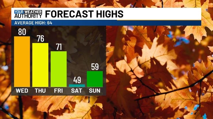
Temperatures will reach the low-to-mid 80s on Tuesday and Wednesday before a strong cold front brings rain and a sharp temperature drop for the weekend.
Temperatures across West Virginia will reach the low-to-mid 80s on Tuesday and Wednesday, representing a significant warm spell. Rain chances will increase late Wednesday afternoon into Thursday as a weather front moves into the area. Humidity will also rise through the period, with dew points climbing into the 60s.
A stronger cold front will sweep through the region on Friday, bringing gusty rain showers and a substantial temperature drop heading into the weekend. Saturday highs will struggle to reach the low-to-mid 50s, marking the coolest afternoon of the season so far. Drier air will move in behind the front.
Sunday morning will see a significant chill, with frost increasingly likely across the region as lows plummet into the mid-30s. Temperatures are expected to return to more seasonable levels for the remainder of the week following the weekend cold snap.
How it is being reported
- Temps near 80 degrees Wednesday with rain showers for the second half of the workweekTemperatures will be near record highs tomorrow, with rain following into the rest of the workweek.WVVA · 13 Oct, 22:09
- WSAZ+ | Summer-like feel mid-week before strong cold frontMeteorologist Dillon Gaudet says temperatures will soar into the 80s for Tuesday and Wednesday. This will be ahead of rain chances increasing by late afternoon Wednesday into Thursday as a front drops into the area.WSAZ · 13 Oct, 14:59
- First Alert Weather | Summer-like feel mid-week ahead of a strong cold frontSummer-like feel mid-week ahead of a strong cold frontWSAZ · 13 Oct, 13:11
- First Alert Weather: Summer-like feel ahead of a cold front late weekDillon Gaudet has your First Alert Weather forecast on this Tuesday morning.WSAZ · 13 Oct, 10:10
- First Alert Weather | Drying out Monday ahead of a mid-week warm upDrying out Monday ahead of a mid-week warm upWSAZ · 12 Oct, 13:09
- First Alert Weather: Drying out Monday ahead of mid-week warm upDillon Gaudet has your First Alert Weather forecast on this Monday morning.WSAZ · 12 Oct, 10:18
In this story: West Virginia · Huntington · Two Virginias · Bluefield · Dillon Gaudet
This summary was written by AI from the headlines and standfirsts above, and states as fact only what at least two outlets report. How we use AI · Report a problem
Comments (0)