High pressure brings sunny weather before weekend front arrives
Summarised from 2 outlets · 4 reports · Updated 14 Oct, 22:32 · Archive
High pressure will keep Florida sunny and dry through the week, with a cold front approaching this weekend bringing rain and stronger winds.
High pressure remains in control over Florida, bringing mostly sunny skies and comfortable temperatures through Thursday and Friday. Highs are expected in the mid-to-upper 80s, with low humidity maintained by northeasterly winds. No significant rain or storms are anticipated during this period, though isolated showers may develop in some areas.
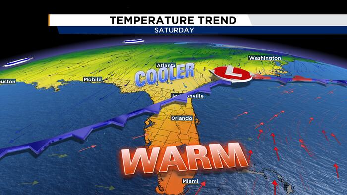
A cold front will begin moving into the region late Friday and into Saturday, bringing increased rain chances and stronger winds. Rain and storm coverage is expected to remain isolated to scattered, with the most widespread activity likely along coastal areas. Clickorlando reports that some storms could produce frequent lightning and gusty winds, though the overall threat for stronger storms remains low. Wind gusts could reach 35 to 40 mph, particularly along the coast.
After the front passes, cooler air will move in, with highs dropping into the low to mid 80s over the weekend. Winds will remain gusty into early next week. The recent rainfall has led to improvement in the regional drought, with several areas being removed from drought categories. Boaters and beachgoers should prepare for rough surf and hazardous marine conditions this weekend.
How it is being reported
- Warm & dry Thursday before rain chances returnWe are tracking a cold front moving into Central Florida this weekend.Clickorlando · 14 Oct, 21:52
- Pleasant weather today before rain and winds ramp up this weekend. Here’s the latestCentral Florida stays warm and mostly dry today, but rain chances increase Friday ahead of a new coldClickorlando · 14 Oct, 11:15
- High pressure keeps our area sunny and dry todayHigh pressure will remain in control today, which means we will see plenty of sunshine and comfortable temperatures. A front will then approach our area this weekend. Right now, rain and storm coverage will remain isolated Friday through the weekend with the most widespread coverage to our south.News4Jax · 14 Oct, 08:56
- High pressure brings sunshine and comfortable weatherHigh pressure will remain in control today, which means we will see plenty of sunshine and comfortable temperatures.News4Jax · 13 Oct, 08:54
In this story: Jacksonville · Central Florida · Orlando · News4Jax
This summary was written by AI from the headlines and standfirsts above, and states as fact only what at least two outlets report. How we use AI · Report a problem
Comments (0)