Hurricane Simon to rapidly intensify before Mexico landfall
Summarised from 2 outlets · Updated 9 Oct, 08:55 · Archive
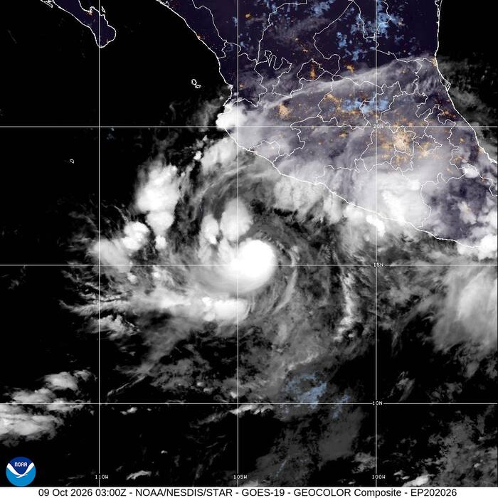
Hurricane Simon is forecast to intensify rapidly from a Category 1 to a Category 4 storm before hitting Mexico's Pacific coast.
Hurricane Simon was heading toward Mexico's Pacific coast on Friday and was forecast to intensify rapidly from a Category 1 to a Category 4 storm before making landfall. The U.S. National Hurricane Center issued a hurricane warning for parts of the central and southwest coast, with hurricane-force winds expected within 36 hours. Early Friday, Simon had maximum sustained winds of 120 kph (75 mph) and was moving northwest at 7 kph (5 mph). The hurricane was centred about 355 kilometres south of Manzanillo and 525 kilometres south-southeast of Cabo Corrientes.
The National Hurricane Center forecast Simon to turn north by early Saturday as it approached the coast. Tropical storm conditions were possible along the coast later Friday. Category 4 hurricanes on the Saffir-Simpson scale have maximum sustained winds of 210–250 kph (130–156 mph). Forecasters warned the hurricane would produce torrential rainfall that could cause flooding and mudslides, with 20 to 38 centimetres of rain expected to fall in southwestern Mexico and isolated areas potentially receiving up to 63 centimetres.
How it is being reported
- Hurricane Simon forecast to get much stronger as it heads to Mexico's Pacific coastHurricane Simon is heading toward Mexico's Pacific coast and forecast to get much stronger.Clickorlando · 9 Oct, 08:14
- Hurricane Simon forecast to get much stronger as it heads to Mexico's Pacific coastHurricane Simon is heading toward Mexico's Pacific coast and forecast to get much stronger.News4Jax · 9 Oct, 08:14
In this story: Hurricane Simon · Mexico · U.S. National Hurricane Center · Manzanillo · Cabo Corrientes
This summary was written by AI from the headlines and standfirsts above, and states as fact only what at least two outlets report. How we use AI · Report a problem
Comments (0)